


Mars’ watery underworld
The fate of Mars’ ancient water has long been debated. Using seismic data from NASA’s InSight lander, Hrvoje Tkalčić and Weijia Sun suggest that much of this water may lie within a hidden reservoir in the planet’s fractured basaltic crust.
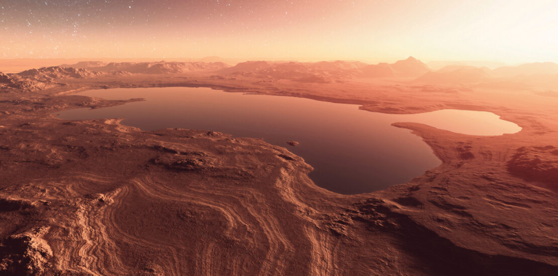
An artist’s impression of an ancient, watery Martian landscape. Billions of years ago, rivers carved intricate valley networks and lakes pooled in craters, yet today Mars is largely dry. Seismic investigations show that much of this ancient surface water may now reside in the subsurface (© iStock).
Mars’ surface bears unmistakable evidence of a wetter past. Images, observations from rovers and studies of meteorites all point towards Mars once having rivers, lakes, deltas, and possibly even oceans. Yet today the planet is largely cold and dry. Where did this water go?
Beneath Mars’ arid, iron-oxide-stained dusty surface may lie a potential clue to our understanding of the red planet’s geological and hydrological history: a reservoir of liquid water, concealed within a porous layer of the upper crust. Using seismic data from NASA’s InSight mission (Banerdt et al., 2020; Lognonné et al., 2019), we worked together with colleagues at the University of Milano-Bicocca, Italy, to identify a seismic ‘low-velocity zone’ lying 5.4–8 kilometres beneath the Martian surface (Sun et al., 2025). We interpret this low-velocity zone as fractured basalt saturated with liquid water – an explanation that addresses the enigma of Mars’ missing water and illuminates the planet’s crustal evolution, thermal dynamics, and potential for hosting life.
Here, we delve into the seismic methodologies we used to uncover this aquifer, our interpretation of the geological processes that shaped it, and the implications of this finding for Martian science and exploration.
Hydrological history
During Mars’ Noachian (4.1–3.7 billion years ago) and Hesperian (3.7–3 billion years ago) periods, rivers carved intricate valley networks, and lakes pooled in craters like Gale and Jezero. Today, observations from orbiting satellites reveal a Martian surface rich in hydrated minerals – clays, sulphates and carbonates – indicative of prolonged, past aqueous activity. Estimates based on geochemical models indicate that this ancient water could have formed a global ocean 710–920 metres deep (Carr and Head, 2015).
Yet, as Mars’ magnetic field waned (approximately 3.9 billion years ago) and its atmosphere thinned during the Amazonian period (starting approximately 3 billion years ago), surface water largely disappeared. Some escaped to space, stripped away by the solar wind, some froze into polar caps, and some became bound in hydrated minerals. These sinks, however, fail to account for the entire ancient water budget, suggesting a significant portion remains hidden.
A water-saturated layer in the upper crust could reshape our view of Mars’ hydrological cycle
It has long been speculated that this ‘missing’ water might reside in the Martian crust (e.g., Ehlmann et al., 2011; Wright et al., 2024). So, using seismic data collected by NASA’s InSight lander, we built a seismic velocity profile for the Martian crust (a graphical representation of the changes in seismic shear-wave velocity with depth through different subsurface layers; see the section below titled ‘Seismic exploration’). Long considered a possibility, this hypothesis now finds support in seismic data: our analyses reveal a distinct low-velocity zone consistent with a water-saturated layer in the upper crust that could reshape our view of Mars’ hydrological cycle.
InSight
Since arriving on Mars in 2018, NASA’s InSight lander has been stationed in Elysium Planitia, a broad plain that straddles Mars’ equator. InSight carries the Seismic Experiment for Interior Structure (SEIS), an incredibly sensitive broadband seismometer that can sense continuous ground motions over a wide range of frequencies. The instrument has recorded more than 1,300 seismic events, including those generated by marsquakes and meteorite impacts (see the section below titled ‘Marsquakes’), enabling unprecedented probing of Mars’ interior.
We analysed high-frequency shear (S) waves from three key events: meteorite impacts S1000a and S1094b from 2021 and the largest recorded marsquake, S1222a, from 2022 (note that ‘S’ in the marsquake ID stands for the solar day, or ‘sol’, on which the event occurred; Fig. 1). These events generated seismic waves up to and above 4 Hz, providing the resolution needed to map crustal structures at fine scale. While earlier analyses also used seismic-wave profiles to probe the structure of the Martian crust, these studies utilised only the lower-frequency portion of the recorded seismic wavefield, mainly below 2 Hz, and thus were unable to image the crust in high resolution.
One limitation of our approach is that only three events had sufficiently high-frequency seismic data for use in our analysis. Similar analyses of seismic data from Earth typically include hundreds of seismic events.
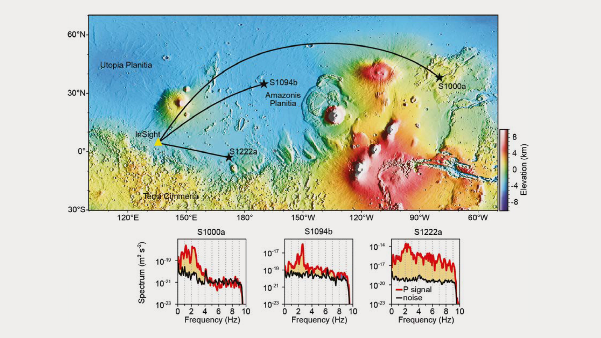
Figure 1 | Location of the InSight station (yellow triangle), impact events S1000a and S1094B and uppermost mantle marsquake S1222a (black stars), as well as the spectral analyses for each event. These three events generated seismic waves with high frequencies up to and above 4 Hz, so could be used to image the finer-scale structure of the crust. The yellow shaded areas highlight P-wave signals (red lines) with strengths greater than the noise level (black lines). (© Sun et al., 2025; Published by Oxford University Press on behalf of China Science Publishing & Media Ltd. under a CC BY license.)
Crustal model
To study the Martian crust, we used teleseismic receiver function (RF) analysis (Fig. 2). InSight’s seismometer records ground motion in three directions, so by removing the vertical component of motion from the radial one, we could identify clear changes in the seismic properties of Mars’ upper crust at depths of 0.8, 5.4, and 8 kilometres.
We used two methods – a best-fit model (deterministic inversion) and a range of possible models with associated likelihoods (Bayesian inversion) – to work out which seismic wave velocity profiles best matched the observed RF profile for the three marsquake events. Both methods pointed to the same result: a well-defined low-velocity zone at the base of the Martian upper crust, between 5.4 and 8 km depth, where S-wave velocities drop to 1.2–1.5 km/s, compared to 2.5–3.5 km/s in surrounding layers (Fig. 2b). To ensure this wasn’t an artifact, we also ran tests using synthetic data, which confirmed the model’s reliability.
Previous analyses using lower-frequency (0.25–2 Hz) marsquake data resolved only a single or double layer within the upper crust (e.g., Shi et al., 2023; Drilleau et al., 2023; Fig. 2c). In contrast, our high-frequency (0.25–4 Hz) approach increased the vertical resolution allowing us to distinguish three layers within the upper crust.

Figure 2 | Inversion of the velocity models. (a) Stacked receiver function waveform plot for sites S1000a, S1094b and S1222a. (b) Deterministic model (black) and Bayesian model (red line) velocity contrasts with depth (Bayesian model probability density function shown in orange). This receiver function analysis reveals clear changes in the seismic properties of Mars’ upper crust at depths of 0.8, 5.4, and 8 km. (c) Comparison of our results with models derived using lower-frequency seismic data, which identified only a simple single or double layered crust. (© Sun et al., 2025; Published by Oxford University Press on behalf of China Science Publishing & Media Ltd. under a CC BY license.)
The shallowest layer (up to 0.8 m depth) we interpret as a fractured layer, likely composed of impact ejecta or altered basalt (Fig. 3). Between 0.8–5.4 km depth, water ice may be present.
The low-velocity layer between 5.4–8 km depth has an S-wave velocity of 1.2–1.5 km/s and an inferred porosity of 20–30% – properties that align with water-saturated basalt (as opposed to dry rock, gas-filled pores, or ice, which would require unrealistic temperature or pressure conditions). Also, the base of the low-velocity zone corresponds to a pressure-thermal regime (45–70 MPa, 10–30°C) in which liquid water is stable under Mars’ geothermal gradient of 6–10°C/km. So, we interpret this as a layer of water-saturated, fractured basalt (Fig. 3).
Such a layer of highly porous (20–30%), basaltic rocks saturated with liquid water is capable of holding a global equivalent layer (water depth if evenly spread over the planet’s entire surface) of 520–780 metres. For comparison, that amount exceeds Antarctica’s ice-sheet equivalent by several times and aligns with the estimated missing water volume for Mars.
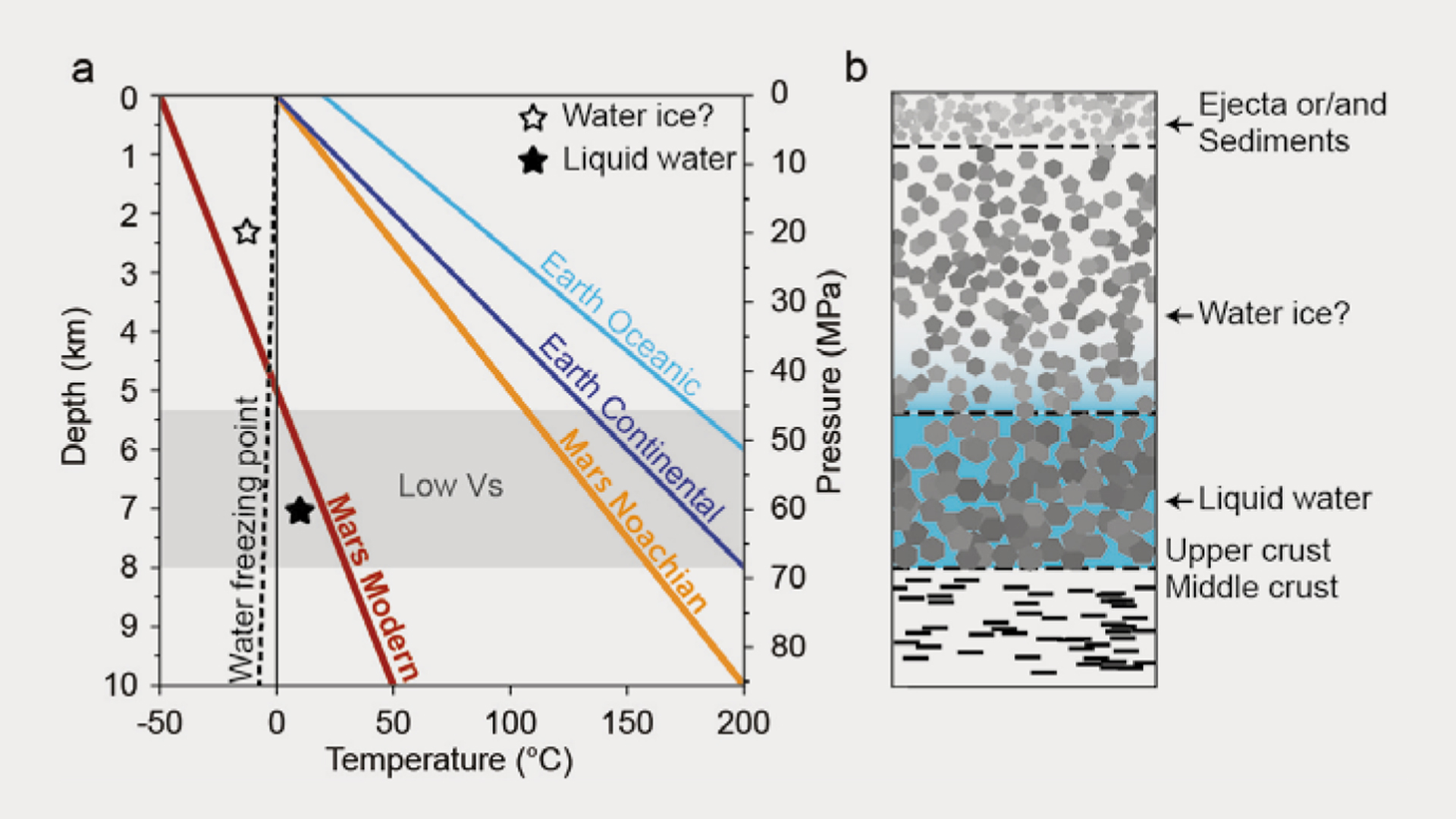
Figure 3 | Water storage model. (a) Thermal profiles for Earth and Mars (adapted from Michalski et al., 2018). Black line, water freezing point with pressure (dashed, pure water; continuous, seawater). Grey, a low-velocity zone indicating the upper crustal base containing liquid water. (b) Schematic model for water storage in Mars’ upper crust. (© Sun et al., 2025; Published by Oxford University Press on behalf of China Science Publishing & Media Ltd. under a CC BY license.)
Geological drivers of water storage
We propose that the low-velocity layer originates from Mars’ early geological history. Noachian meteorite bombardment fractured the basaltic crust, creating a porous network with permeabilities akin to terrestrial aquifers. Once created, these fractures may have been subsequently reactivated by planetary contraction due to Mars’ cooling. As surface water diminished, it infiltrated these fractures, pooling at depths where geothermal gradients maintain temperatures above the freezing point of pure water or brine (0–30°C at 5–8 km). Sequestered into deep reservoirs, liquid water could persist at these depths (unlike the frozen near-surface layers).
Water-rock interactions likely altered the crust, forming hydrated minerals like clays or zeolites, which further reduce seismic velocities. These processes mirror terrestrial hydrothermal systems, where water reacts with basalt to produce serpentine or carbonates, potentially enriching the subsurface with biologically relevant elements (Ehlmann et al., 2011). Such interactions could have sustained habitable environments during Mars’ wetter epochs, with implications for modern geo/astrobiology.
Astrobiological and exploration implications
Liquid water is a prerequisite for life as we know it. On Earth, microbes thrive in deep aquifers. These organisms rely not on sunlight, but on chemosynthesis, exploiting energy from water–rock interactions such as serpentinization, sulfate reduction, or iron redox cycling. The Martian water-saturated layer identified at ~5–8 km depth could provide a comparable environment. If the water is briny and chemically enriched with sulfur or iron, it could generate metabolic energy sources similar to those used by Earth’s deep microbes and preserve relics of Noachian life.
Future missions, such as NASA’s proposed Mars Life Explorer, would drill to subsurface depths of two metres to analyse water chemistry for biosignatures like organic molecules or isotopic anomalies. For human exploration, the aquifer offers a vital resource too. Extracted water could support drinking, oxygen production, or hydrogen fuel synthesis, reducing reliance on Earth’s supplies. Advanced robotics and power systems would be required to make drilling to depths of 5-8 kilometres a more achievable endeavour, given the challenges experienced when attempting to drill to similar depths here on Earth. Shallower water-rich zones, like Utopia Planitia’s ice deposits (estimated to lie at depths of 10 metres), may provide interim resources.
Hurdles and horizons
The InSight seismic waveform data, which are limited to Elysium Planitia, provide a local snapshot of the Martian subsurface. Lateral variations in crustal structure due to regional differences require global or at least regional seismic surveys. A proposed Mars Geophysical Network with multiple seismometers could one day help constrain the extent of the aquifer, while orbital radar and gravimetry data could refine porosity estimates.
Beneath its dusty surface, Mars may still pulse with the echoes of ancient oceans
Notably, InSight’s magnetometer, designed to measure variations in the magnetic field, did not detect signatures of the layer of water mixed with rocks that we propose. Water exhibits weak diamagnetic properties, meaning it is slightly repelled by magnetic fields, producing subtle effects detectable only with highly sensitive instruments or strong magnetic fields. The absence of a clear magnetic signal from 5.4–8 km depth underscores the challenge of detecting subsurface water via magnetometry because the stronger magnetic signatures of Martian regolith and crustal rocks might mask the diamagnetic response. Future missions could integrate advanced magnetometers with higher sensitivity, alongside seismic and radar data, to better constrain the distribution and properties of these hidden aquifers.
Our inference of a water reservoir at the base of Mars’ upper crust also raises questions about the planet’s thermal evolution. Sustaining liquid water (although contained within the rocks’ pores and fractures) at ~5–8 km depth implies that the geothermal gradient in this region is sufficient to maintain liquid stability, possibly driven by radiogenic heat or localised volcanic activity. Integrating seismic data with thermal models will be crucial to constrain these parameters.
Nevertheless, the seismic hint of liquid water in our study marks one of the turning points in our exploration of Mars using a single seismometer. Our analysis suggests that the upper crust might be concealing a reservoir preserving the planet’s hydrological past. By refining seismic techniques and planning new missions, we can unlock the secrets of Mars’ subsurface, probing its potential for life and resources. As we listen to the seismic wavefield reverberations from the red planet’s subsurface layers, we glimpse a world that, beneath its dusty surface, may still pulse with the echoes of ancient oceans.
Authors
Professor Hrvoje Tkalčić, Australian National University, Australia
Professor Weijia Sun, Chinese Academy of Sciences, China
Seismic exploration
By examining the travel times, waveform shape, attenuation, scattering and dispersion of shear (S) waves generated by local or distant (teleseismic) events, S-wave analyses enable reconstruction of the structure (including temperature and compositional variations) of a planet’s subsurface and interior. Teleseismic receiver function (RF) analysis primarily uses compressional (P) waves from distant events and focuses on points where fast P-waves convert into slower S-waves as they pass through underground layers, so is particularly useful for identifying subsurface boundaries.
Low to very low-frequency seismic wave analysis is typically best for imaging the deeper, broad-scale variation within a planet, whereas high-frequency seismic wave analysis is typically best for resolving more localised, near-surface and fine-scale structures.
Marsquakes
Unlike Earth, Mars does not have active plate tectonics. Instead, marsquakes are triggered by the sudden release of energy accumulated by crustal stresses built up over billions of years of planetary evolution or due to tidal stresses induced by the planet’s two moons, or resulting from thermal expansion and contraction (associated with large volcanoes such as Olympus Mons or in the Tharsis Montes region). Meteorite impacts also generate seismic waves.
Most ‘terrestrial-looking’ marsquakes originate from the fissured Cerberus Fossae region, where tectonic and potentially volcanic stresses appear to concentrate along deep fissures. We have recently also documented another significant cluster of marsquakes in the heavily cratered Terra Cimmeria region south of the InSight lander (Sun and Tkalčić, 2025).
Further reading
- Banerdt, W.B. et al. (2020) Initial results from the InSight mission on Mars. Nat. Geosci. 13, 183–189; 10.1038/s41561-020-0544-y.
- Carr, M.H. & Head, J.W. (2015) Martian surface/near-surface water inventory: Sources, sinks, and changes with time. Geophysical Research Letters 42, 726–732; 10.1002/2014GL062464.
- Drilleau, M. et al. (2023) Structure of the Martian crust below InSight from surface waves and body waves generated by nearby meteoroid impacts. Geophysical Research Letters 50, e2023GL104601; 10.1029/2023GL104601.
- Durán, C. et al. (2022) Seismology on Mars: an analysis of direct, reflected, and converted seismic body waves with implications for interior structure. Physics of the Earth and Planetary Interiors 325, 106851; 10.1016/j.pepi.2022.106851.
- Ehlmann, B.L. et al. (2011) Subsurface water and clay mineral formation during the early history of Mars. Nature 479, 53–60; 10.1038/nature10582.
- Hu, S. et al. (2024) Water and other volatiles on Mars. National Science Review 11(6), nwae094; 10.1093/nsr/nwae094.
- Jakosky, B.M. (2021) Atmospheric loss to space and the history of water on Mars. Annual Review of Earth and Planetary Sciences 49, 71–93; 10.1146/annurev-earth-062420-052845.
- Joshi, R. et al. (2023) Joint inversion of receiver functions and apparent incidence angles to determine the crustal structure of Mars. Geophysical Research Letters 50, e2022GL100469; 10.1029/2022GL100469.
- Knapmeyer-Endrun, B. et al. (2021) Thickness and structure of the Martian crust from InSight seismic data. Science 373, 438–43; 10.1126/science.abf8966.
- Lognonné, P. et al. (2019) SEIS: Insight’s Seismic Experiment for Internal Structure of Mars. Space Sci Rev 215, 12; 10.1007/s11214-018-0574-6.
- Michalski, J.R. et al. (2018) The Martian subsurface as a potential window into the origin of life. Nature Geosci 11, 21–26; 10.1038.
- Shi, J. et al. (2023) High-frequency receiver functions with event S1222a reveal a discontinuity in the Martian shallow crust. Geophysical Research Letters 50, e2022GL101627; 10.1029/2022GL101627.
- Sun, W. & Tkalčić, H. (2025) Constraints on the origin of the Martian dichotomy from Southern Highlands marsquakes. Geophysical Research Letters 52, e2024GL110921; 10.1029/2024GL110921.
- Sun, W. et al. (2025) Seismic evidence of liquid water at the base of Mars’ upper crust. National Science Review 12 (6), nwaf166; 10.1093/nsr/nwaf166.
- Wright, V. et al. (2024) Liquid water in the Martian mid-crust. PNAS 121 (35) e2409983121; 10.1073/pnas.2409983121.
Citation: Tkalčić, H. and Sun, W. Mars’ watery underworld. Geoscientist 35 (4), 14-20, 2025. DOI: 10.1144/geosci2025-031


