Disappearing geological exposures
A national, open-access database is needed to prevent the loss of data from geological exposures, argues John Collinson
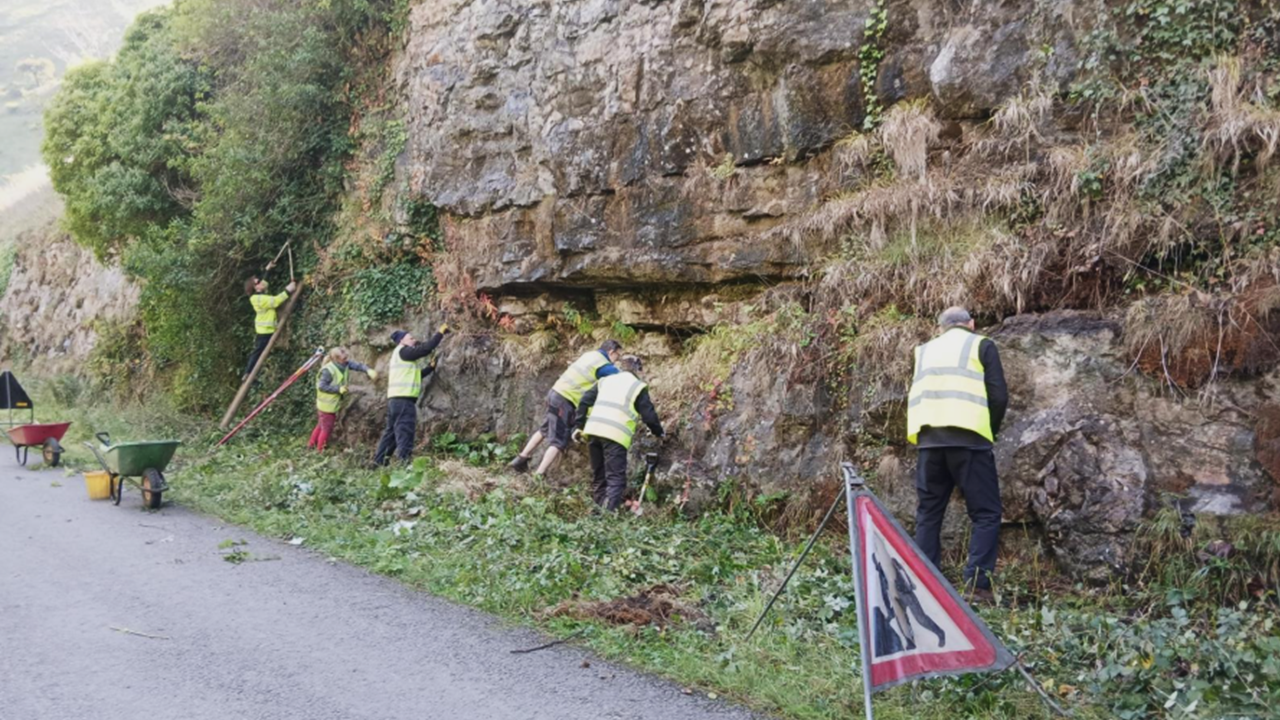
Volunteers clear vegetation off limestone exposures along the Monsal Trail, Peak District National Park. (© Dave Watts)
Recently, while preparing a guidebook on the Southern Pennines, I revisited several key geological localities after many years away. Sadly, I discovered that significant exposures either no longer merited inclusion in the guidebook or warranted only scaled-back details due to poor visibility from the encroachment of vegetation, conversion of quarries to landfill and installation of barriers to access. Some of these exposures have been important for understanding regional geology, so their loss is highly regrettable. We should now be taking steps to collect and preserve data for future geologists to evaluate critical exposures when they are no longer accessible.
Prioritising preservation
We should prioritise preservation of what is still accessible and visible. Given permission, goodwill and enthusiasm, vegetation can be controlled, as shown by volunteer work parties that have helped manage exposures in the Peak District, Derbyshire (in conjunction with the National Park), where old quarries are also maintained by the British Mountaineering Council. Landfill sites may be more challenging to tackle unless preservation of geologically important features is made a condition of planning approvals.
Sites that are already or will shortly be lost require collation of available records and collection of new data, where appropriate. Historical data are likely to be photographs that can be digitised and, in some cases, processed further. Digital models of geological localities are increasingly constructed based on high-resolution LiDAR remote sensing technology, both ground-based and from drones. Many such models come from “clean” settings, such as coasts or deserts where scanners encounter little obstruction from vegetation, so “clean” inland exposures, such as working or recently abandoned quarries, could be scanned with similar success. Ideally, the production and archiving of digital models from high-resolution scanning would be mandatory for abandonment protocols of quarries and other significant excavations (such as road building).
Settings with significant encroachment by vegetation are more challenging. However, a combination of physical clearance and fresh scans may generate useful data, especially when obstructing vegetation can be edited from the digital models.
Open-access database
We should aim to build a national, open-access database of digital models. Ideally, this would be administered by a national organisation, such as the British Geological Survey, in a similar way to its core photographs database from North Sea wells. Models created as part of university research projects would be routinely deposited in the database, with access rules like those for PhD theses.
So, how might the collection and compilation of such data be organised? Given the rapidly deteriorating state of many exposures, data collection could be implemented at a local level by regional groups, societies and universities. Hopefully, national standards for data formats would evolve through accumulated experience. The collection of new data would require access to scanners, drones and operator expertise, as well as proficiency with appropriate software; the involvement of universities seems natural as several already have high-level expertise and models acquired for research projects.
To establish a comprehensive database that preserves important geological exposures will involve overcoming funding, organisational and political challenges; but every journey begins with a single step in the right direction.
Author
Dr John Collinson
Retired sedimentology and reservoir geology consultant, formerly affiliated with Keele University, UK, and the University of Bergen, Norway.
Further reading
-
- An earlier version of this article was published in the Yorkshire Geological Society Circular No.652.
- John Collinson and Brian Roy Rosen (2024) The Southern Pennines: Classic Geology in Europe 13. Liverpool University Press, 384 pp. (Available from Geoscientist’s bookshop)