The open geoscience revolution
Much of the UK’s geological data are more accessible than most realise. Colleagues from Haskoning and The Crown Estate explain how openness is driving research and innovation in offshore wind development

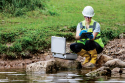
Open data and collaboration are powering the UK’s off shore wind sector, turning the seabed into a shared resource for science and innovation (© The Crown Estate / Ben Barden).
For many years, a common assumption in the geoscience community has been that the most valuable geological data sits behind closed doors. Researchers often presume that subsurface development data are confidential and difficult to access and, with limited funding or resources, they have sometimes struggled to maximise research using these vast geophysical and geotechnical datasets.
In contrast, the development-led research funded by industry focuses on the needs of a specific development and is conducted on commercial timelines, leaving little time or scope to explore the wider scientific insights these datasets might offer—even though many in industry recognise their broader value for understanding Earth systems.
However, these perceptions are increasingly out of date. Over the past decade, attitudes and practices around data sharing have shifted significantly. Industry, government bodies and researchers are working together far more openly, creating new opportunities for knowledge and data exchange that benefit science, infrastructure development and the transition to a clean energy future. Here we highlight some examples of data sharing and innovation in the offshore wind sector.
A new wave of collaboration
Joint collaborations between industry, academia and government have long been common in the hydrocarbon sector. However, similar relationships in the renewables sector are emerging, reflecting the rapid pace of the energy transition. In recent years, this gap has begun to close. Collaboration during offshore wind research projects has visibly increased, and greater data sharing is helping to accelerate innovation, open new geoscience research opportunities, support environmental planning, and reduce costs and development risks.
Recent examples of this growth in offshore wind industry-research collaborations include a joint programme between the University of Leeds and developers at the energy companies RWE, Vattenfall and SSE Renewables to build a three-dimensional ground modelling workflow using publicly available offshore wind datasets.
In another example of collaborative data collection, Bangor University worked with RWE to utilise offshore data collected by the university’s survey ship Prince Madog to map the seabed in the Awel y Môr extension project off the coast of Wales.
Shared datasets are also supporting fundamental geoscience research. British research funded by the European Research Council used offshore wind data from the Netherlands Enterprise Agency (RVO, a Dutch government agency that supports entrepreneurs, NGOs, and researchers in sustainability, innovation, and global business) to better understand the history of ice advance and retreat in the southern North Sea.
Other projects focus on practical engineering challenges. One at Durham University, funded through the University of Hull’s Aura Centre for Doctoral Training (auracdt.hull.ac.uk) is using open datasets from UK offshore wind farms (including borehole logs and geotechnical data) to develop viable removal strategies for monopile foundations (large steel columns that anchor turbines to the seabed) at end-of-life.
Collaboration during off shore wind research projects has visibly increased, and greater data sharing is helping to accelerate innovation, open new geoscience research opportunities, support environmental planning, and reduce costs and development risks
At the same time, shared datasets are enabling new analytical approaches. The Crown Estate (TCE; an independent commercial business that manages land, property and the seabed across England, Wales and Northern Ireland) is working with the University of Glasgow to develop machine learning tools for offshore geotechnics.
These collaborations not only drive research and innovation but also highlight the importance of expertise. Seabed geology data require careful interpretation by specialists, making skills transfer crucial for supporting renewable infrastructure and strengthening the UK’s marine economy.
Data sharing initiatives also play a vital role in training the next generation of geoscientists. Access to real-world industry datasets allows students and researchers to work with the kinds of data they will encounter in practice, bridging the gap between academic training and industry needs. This strengthens the future workforce and supports growth across the geosciences, while aligning with the UK’s net-zero ambitions.
Driving open data
Another significant shift has come from TCE, which for more than two decades has worked with offshore developers to promote data sharing, building trust across the sector while helping establish consistent processes and data-management standards.
The creation more than a decade ago of the Marine Data Exchange, the world’s largest, publicly accessible repository of marine survey data (marinedataexchange.co.uk), is built on strong relationships between TCE, developers and stakeholders. The platform allows industry to not only store survey data, but to make it openly accessible to the wider marine community. The Marine Data Exchange recently underwent a major overhaul, improving access, usability and searchability. This reflects a growing recognition that reusing existing data is often the fastest and most cost-effective way to meet new evidence needs.
Better data, better decisions
TCE is responsible for identifying sites for future offshore wind development that support the UK’s world-leading sector, while integrating nature as a priority through its Marine Delivery Routemap and Guiding Nature Principles. As a result, the datasets and evidence that underpin these decisions are more important than ever.
Seabed geology plays a fundamental role in bringing forward technically feasible, commercially attractive and low-risk development sites. TCE uses national-scale data on ground conditions and geohazards to inform spatial assessments of cost of energy and technical risk. However, the best available national-scale datasets are now more than a decade old. In 2024, TCE collaborated with the British Geological Survey and other stakeholders to identify the highest priority data needs for the future. These priorities have already led to several new projects aimed at updating the national datasets that underpin critical decision-making across the UK.
TCE, together with professional services firm WSP, is leading the development of a national-scale integrated ground model. This model brings together multiple data layers used in cost and risk modelling, feeding directly into spatial planning and design. Geological, geotechnical and geophysical datasets from the Marine Data Exchange have been integrated into the model, significantly improving the characterisation of subsurface conditions and geohazards and helping reduce risks associated with developing future wind farm sites.
De-risking the future
This shift towards proactive data collection and sharing is also shaping how new offshore wind developments are planned. Offshore Wind Leasing Round 5 will establish a new floating wind sector in the Celtic Sea. In recognition of the need to bring floating wind on-stream as soon as possible, TCE launched a multi-million-pound programme of technical and environmental marine surveys to accelerate and de-risk the seabed for Round 5 projects. By investing in these early-stage surveys, including geophysical and geotechnical campaigns, developers should be able to take early decisions and proactively manage risk associated with developing their awarded site. All these data will be shared through the Marine Data Exchange and therefore be freely available for research.
Greater openness does not mean that all data can or should be public. Concerns about foreign interference and geopolitical risks demonstrate why some subsurface information must remain protected. There will always be cases where national-level security considerations restrict open publication. The challenge is to strike the right balance: sharing as much as possible to drive innovation, while safeguarding information vital to national security.
A connected future
These developments point towards a more collaborative, accessible and strategically aligned future for geoscience. The field is moving away from a culture where data were assumed to be restricted, towards one where sharing is increasingly expected.
The benefits ripple outward: better spatial planning, stronger environmental assessments, more confident engineering decisions, and improved workforce training. Perhaps most importantly, greater openness allows society to extract far more value from the data that already exists beneath our seas and coastlines.
Data sharing is no longer simply a technical consideration—it is becoming a cornerstone of progress across science, energy and society.
Unlocking the full potential
As demands on the UK’s seabed and coastline continue to grow, so too does the need for a more coordinated, systems-led approach supported by strong evidence. TCE’s Marine Delivery Routemap uses the best available data across the seabed to model and map potential future uses of marine space around England, Wales and Northern Ireland over the coming decades. A key objective is making information easier to find and compare, and more useful for decision-making. Despite this progress, several challenges remain:
- Considering impact pathways and stakeholders from the outset to ensure research outputs align with users’ needs. Providing geoscience data in formats suitable for engineers and communicating findings in accessible ways.
- Maintaining and updating UK-collected geoscience data to keep datasets relevant as user needs evolve. Ensuring physical samples, such as marine sediment cores, can be stored and distributed efficiently despite limited space in the National Geological Repository (Condon & Bee, 2026) and British Ocean Sediment Core Research Facility (National Oceanography Centre, 2025).
- Increasing visibility of improvements (such as the recent Marine Data Exchange reforms) to raise awareness of available datasets and support collaboration.
- Demonstrating the benefits of data sharing by collecting evidence of how improvements have supported other geoscience sectors and delivered wider societal value.
- Coordinating research programmes to reduce duplication, improve operational efficiency, and lower costs.
- Innovating data collection and processing while balancing efficiency with environmental impact. Ensuring resource-intensive approaches, including AI, are applied responsibly to minimise carbon footprint.
- Developing technical expertise and workforce capacity through sustained investment in skills and training for both emerging geoscientists and professionals transitioning to the energy sector.
Authors
Claire Mellett Technical Director at Haskoning, UK
Chelsea Bradbury Senior Marine Data and Insights Manager at The Crown Estate, UK
Natasha Barlow Technical Director at Haskoning, UK
Michael Blair Principal Engineering Manager at The Crown Estate, UK
Further reading
- Barlow, N. & Hodgson, D. (2021) To harness the North Sea winds, we must understand its complicated seabed geology. The Conversation; doi.org/10.64628/AB.4v77xqgur
- Cartelle, V. et al. (2021) Sedimentary architecture and landforms of the late Saalian (MIS 6) ice sheet margin offshore of the Netherlands. Earth Surface Dynamics, 9 (6), 1399–1421. doi.org/10.5194/esurf-9-1399-2021
- Condon, D. & Bee, E. (2026) Core knowledge: Valuing the UK’s geological archive. Geoscientist, 36 (1), 32-36; doi.org/10.1144/geosci2026-005
- Dakin, N. et al. (2026) The shallow subsurface geology of the southern North Sea (UK): an updated assessment using data from offshore wind farms. Edinburgh, UK, British Geological Survey, 84 pp. (OR/26/005) (Unpublished) The shallow subsurface geology of the southern North Sea (UK): an updated assessment using data from offshore wind farms – NERC Open Research Archive; nora.nerc.ac.uk/id/eprint/541271
- DiCenzo, C. et al. (2024), The importance of archiving the seafloor, Eos, 105; doi.org/10.1029/2024EO240020
- National Oceanography Centre (2025) Written evidence SDY0039 submitted to Parliament 9th May 2025. committees.parliament.uk/writtenevidence/141653/html
- The Crown Estate Marine Delivery Routemap; thecrownestate.co.uk/our-business/marine/Marine-Delivery-Routemap
- Velenturf, A. et al. (2021) Geoscience solutions for sustainable offshore wind development. Earth Science, Systems and Society, 1 (1), 10042; doi.org/10.3389/esss.2021.10042